Hiroshima: Memorials and a Modern City

Hiroshima, the Japanese city forever linked with history.  As the site of the first use of a nuclear weapon on a city, it’s impossible not to think of World War II when hearing the word Hiroshima.  The atomic bomb dropped on Hiroshima on August 6, 1945 and afterwards the city and the world was never the same.  First time visitors to Hiroshima wonder what they will find upon arriving in the city.  Hiroshima has rebuilt itself from the ashes of destruction into a beautiful and modern city, one whose mission now is to spread the message of peace to the world.

Welcome to Hiroshima

The easiest way for visitors to reach Hiroshima is by train.  From Kyoto, visitors can arrive in Hiroshima in just under three hours.  Once you arrive at Hiroshima Station exit via the South Gate and head to the city’s main form of public transportation, the streetcar (Hiroshima Electric Railway).  These trams ride through the city on railway tracks.  The streetcar’s run on nine, color coded, routes that cut through the entire city and will have you at your destination in no time.

Hiroshima’s streetcars are fast, efficient, and easy to use.  Passengers need not buy tickets before boarding the streetcar.  Board the streetcar through the door marked “entrance”.  Smaller streetcars have entrance doors at the back of the tram.  Longer streetcar’s entrances will be in the middle of the tram.  When you arrive at your stop, disembark via the exit doors near either the driver or the conductor.  Before exiting deposit the flat rate for inner city travel, 160 yen, in the provided coin slot.  Those without exact fare will receive their change from the coin slot machine.

If you plan on using the streetcars multiple times in one day, consider buying a day pass.  Day passes are available to buy before entering the streetcar or on board from the conductor.  A day pass for adult riders is 600 yen and 300 yen for children.  For those that need unlimited rides in the city and ferry access to nearby Miyajima, a one day streetcar and ferry pass is available.  This pass costs 840 yen for adults and 420 yen for children.

Signpost with the inscription "May Peace Prevail on Earth" - Hiroshima, Japan

Signpost with the inscription “May Peace Prevail on Earth”

Peace Memorial Park

On August 6, 1945 at 8:15am the United States dropped an atomic bomb on the city of Hiroshima.  With the city reduced to ruins, the significant impact of what happened that day permeates the city.  Yet from the destruction a beautiful remembrance to the victims and a beacon of peace has arisen.  The Peace Memorial Park ensures visitors never forget that infamous day and gives hope that the event that transpired never happens again.  As you approach the Peace Memorial Park, you should see a sign post that reads “May Peace Prevail on Earth”.  Repeat this phrase in your mind as you walk through the various memorials built to remember what occurred there.

Those visitors that wish to learn the history of the atomic bomb being dropped on Hiroshima will want to visit the Peace Memorial Museum.  After the Museum head to one of the main memorials, the Cenotaph for the Atomic Bomb Victims.  This stone chamber, in the middle of the Park, has a list of the victims who died by the atomic bomb.  From the Cenotaph, you can see, and walk to, the Peace Flame.  The Flame will continue to burn until no more nuclear weapons exist on Earth.

Children's Peace Monument - Hiroshima, Japan

Children’s Peace Monument

Children’s Peace Monument and Other Memorials

The Children’s Peace Monument is a memorial for the children who died because of the atomic bomb.  A girl by the name of Sadako Sasaki inspired others to create the Children’s Peace Monument.  In 1955, Sadako was twelve years old and diagnosed with leukemia.  The disease resulted from her exposure to the radioactive aftereffects of the atomic bomb when she was two years old.  Sadako believed if she folded a thousand cranes she could defeat the leukemia.  Sadako could not beat the sickness, she died the same year as her diagnosis.  Classmates of Sadako’s petitioned to have the memorial built and ever since people from around the world have continued Sadako’s tradition of making paper cranes.  Glass boxes surround a statue of Sadako and contain every paper crane ever made in remembrance of Sadako and the children who died because of the atomic bomb.

Other notable memorials include the Korean Victim Monument, A-bombed Gravestone, Atomic Bomb Memorial Mound, the Bell of Peace, and the Peace Clock Tower.  The Peace Clock Tower chimes quarter past eight every morning, the same time as when the blast occurred on August 6, 1945.  Across the river, the A-Bomb Dome is the only remaining building from before the atomic bomb dropped.  Prior to the bombing the building was the Hiroshima Prefectural Industrial Promotion Hall.  Now, all that remains of the building are structural beams and blown out walls.  Flood lights used at night illuminate the remains of the building.  Near A-Bomb Dome is the Aioi Bridge. Aioi Bridge was the target of the bombing because of its distinctive “T” shape.

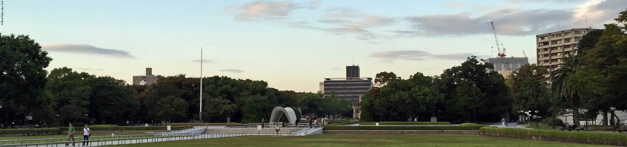
Modern Day Hiroshima

The memorials draw visitors to Hiroshima to remember and to pledge to bring peace to the entire world.  Around the Peace Memorial Park is a metropolitan city.  Rebuilt after the war, Hiroshima has modern buildings around the Park.  Here you will find the residents of Hiroshima living out their daily routines.  Among the buildings you’ll find shopping arcades and restaurants serving traditional Japanese dishes, such as okonomiyaki and ramen, made with a Hiroshima twist.

Modern day Hiroshima - Hiroshima, Japan

Modern day Hiroshima

Besides buildings, shopping arcades, and restaurants what you will find are the country’s friendliest people.  Hiroshima locals are quick to smile and offer help to visitors from every corner of the world.  The heart wrenches thinking of the utter destruction that befell this city, and yet it warms the heart to know beauty has come from such destruction.  The beauty of the Peace Memorial Park and the inner beauty of the Hiroshima people gives us hope that one day peace will prevail over the entire globe.

Hiroshima Memorials

loading map - please wait...

Hiroshima Station: 34.396228, 132.475438
Hiroshima Peace Memorial Museum: 34.391521, 132.453064
Cenotaph for the Atomic Bomb Victims: 34.392976, 132.452573
Peace Flame: 34.393445, 132.452776
Children\'s Peace Monument: 34.394103, 132.452976
Korean Victim Monument: 34.394208, 132.451847
A-bombed Gravestone: 34.394208, 132.451847
Atomic Bomb Memorial Mound: 34.394650, 132.452025
Bell of Peace: 34.394865, 132.452397
A-Bomb Dome: 34.395464, 132.453471
Peace Clock Tower: 34.395415, 132.452370
Aioi Bridge: 34.396198, 132.453403
marker icon
icon-car.png
Hiroshima Station
Hiroshima: Memorials and a Modern City
広島駅, Hiroshima-shi, Japan
marker icon
icon-car.png
Hiroshima Peace Memorial Museum
Hiroshima: Memorials and a Modern City
広島平和記念資料館 (Hiroshima Peace Memorial Museum), Hiroshima-shi, Japan
marker icon
icon-car.png
Cenotaph for the Atomic Bomb Victims
Hiroshima: Memorials and a Modern City
原爆死没者慰霊碑 (Cenotaph for the A-bomb Victims), Hiroshima-shi, Japan
marker icon
icon-car.png
Peace Flame
Hiroshima: Memorials and a Modern City
広島平和記念公園 (Hiroshima Peace Memorial Park), Hiroshima-shi, Japan
marker icon
icon-car.png
Children's Peace Monument
Hiroshima: Memorials and a Modern City
原爆の子の像, Hiroshima-shi, Japan
marker icon
icon-car.png
Korean Victim Monument
Hiroshima: Memorials and a Modern City
韓国人原爆犠牲者慰霊碑, Hiroshima-shi, Japan
marker icon
icon-car.png
A-bombed Gravestone
Hiroshima: Memorials and a Modern City
韓国人原爆犠牲者慰霊碑, Hiroshima-shi, Japan
marker icon
icon-car.png
Atomic Bomb Memorial Mound
Hiroshima: Memorials and a Modern City
原爆供養塔 (Atomic Bomb Memorial Mound), Hiroshima-shi, Japan
marker icon
icon-car.png
Bell of Peace
Hiroshima: Memorials and a Modern City
平和の鐘, Hiroshima-shi, Japan
marker icon
icon-car.png
A-Bomb Dome
Hiroshima: Memorials and a Modern City
原爆ドーム, Hiroshima-shi, Japan
marker icon
icon-car.png
Peace Clock Tower
Hiroshima: Memorials and a Modern City
平和の時計塔, Hiroshima-shi, Japan
marker icon
icon-car.png
Aioi Bridge
Hiroshima: Memorials and a Modern City
Hiroshima Tokushimaken, Japan

Save

Save

Save

Save

Save

Save

Save

Save

Save

Save


Impressions and Sights of Osaka, Japan

Osaka is the city often overlooked by visitors to the country of Japan. The flashier Tokyo or the temples of Kyoto draw millions of tourists, yet those that stay away from Osaka are missing out. Walk around Osaka and you will find yourself in a beautifully understated city.  Morning-to-night locals and tourists alike enjoy every corner of Osaka. As with any other top-notch city you will find plenty of shopping, great eats, wondrous sights, and an active nightlife.

With easy access from Kansai International Airport, Osaka is a great starting point for your trip. This is especially so if you are primarily focusing your trip on the Kansai region of Japan. If you have just arrived in Japan, Osaka is a great city to sync up into the rhythm of Japan and help you get over your jet lag. From Kansai International Airport take the Kansai Airport Express JR Haruka and you will reach Osaka within an hour.

Numbers of Days to Spend in Osaka

Although Osaka is not nearly as overwhelming in size and scope as Tokyo, you will still need at least three full days to capture the essence of the city. Two days are only enough if your focus is on sightseeing, as Osaka has fewer sights than Tokyo or Kyoto. If you enjoy eating and shopping, two days will go by in the blink of an eye. To truly experience Osaka you will be happy you added a third or even a fourth day in this relaxed and laid back big city. Osaka has multiple districts and you might miss a couple of districts if you are trying to cram everything of import into just two days.

Those that enjoy the nightlife will want to schedule their trip to Osaka to coincide with the weekends. Fridays and Saturdays are popular nights with people enjoying the city late into the evening and into the next morning. Partygoers will find plenty of bars and clubs in the city. Even late at night, popular restaurants have long lines of foodies and partygoers looking to fuel up on good food. Or if the evening air is warm enjoy walking the streets and the water-lined walkways of Dotonbori canal while soaking in the atmosphere that is Osaka.

Osaka Castle Park

The top sight in Osaka is Osaka Castle Park. The grounds of the Park are free to visitors. From the grounds you can get great photos of the various buildings on the grounds, including the main Castle itself. Entry into the Castle will cost an admission fee. Osaka Castle Park is a great place to visit during the spring or fall time. At those times of the year the grounds come alive with cherry blossoms or the autumn colors of the turning of the tree leaves.

Umeda Sky Building

Visit the Umeda Sky Building for amazing views of the city. This architectural astonishment, in the shape of an upside-down U, has a viewing platform on the very top floor. Ride an elevator, followed by a short escalator ride, to the 173rd floor and the Floating Garden Observatory. Take in views of the city by sitting inside on the various seating available or by heading outside to stand on the viewing platform. Whether inside or outside, you will be in for a treat, with stunning panoramic views of the city of Osaka.

After you’ve enjoyed the views of the city, ride the elevator to the bottom of the Umeda Sky Building. Under the Umeda Sky Building you will find Takimi Koji Alley. This floor is a recreation of an old Japanese town, with “streets” that house various restaurants and izakaya. Enjoy this peaceful section of Osaka as you stroll the “streets” and unwind while eating fantastically good food.

Dotonbori Walk

Dotonbori, or Dotombori, is one of the main districts of Osaka. This popular part of town runs along the Dotonbori canal, making this a picturesque part of the city to walk. Dotonbori is close to a section of the city known as Amerika-Mura. Here you will find a hip youthful vibe with stores selling new and used/vintage clothes. For neon lights, restaurants with big signs made to appear as food, and more shops visit the parts of Ebisu-bashi and Dotonbori Arcade. For even more stores you can stop by Shinsaibashi Station. If you need a break from the active buzz of the city, be sure to visit Hozen-ji Temple, a serene spot in the city.

Namba Yasaka shrine - Osaka, Japan

Namba Yasaka shrine

Osaka Shrines

The shrines of Osaka are peaceful oases in the bustling city. If you visit only one shrine, be sure to visit Namba Yasaka. The grounds for this Shinto shrine are small but the massive lion head makes the trip worthwhile. Use the time at the shrine for peaceful contemplation before heading back into the city.

Osaka Sights

loading map - please wait...

Osaka Castle Park: 34.687315, 135.526201
Umeda Sky Building: 34.705384, 135.489614
Dotonbori: 34.668515, 135.502552
Ebisu-bashi: 34.669054, 135.501296
Shinsaibashi Station: 34.674413, 135.500310
Hozen-ji Temple: 34.667877, 135.502613
Namba Yasaka Shrine: 34.661625, 135.496691
marker icon
icon-car.png
Osaka Castle Park
Impressions and Sights of Osaka, Japan
Osaka Castle Park, Osaka, Osaka Prefecture, Japan
marker icon
icon-car.png
Umeda Sky Building
Impressions and Sights of Osaka, Japan
Umeda Sky Building, Osaka, Osaka Prefecture, Japan
marker icon
icon-car.png
Dotonbori
Impressions and Sights of Osaka, Japan
Dotonbori, Osaka, Osaka Prefecture, Japan
marker icon
icon-car.png
Ebisu-bashi
Impressions and Sights of Osaka, Japan
Ebisubashi, Osaka, Osaka Prefecture, Japan
marker icon
icon-car.png
Shinsaibashi Station
Impressions and Sights of Osaka, Japan
Shinsaibashi Station, Osaka, Osaka Prefecture, Japan
marker icon
icon-car.png
Hozen-ji Temple
Impressions and Sights of Osaka, Japan
Hōzen-ji Temple, Osaka, Osaka Prefecture, Japan
marker icon
icon-car.png
Namba Yasaka Shrine
Impressions and Sights of Osaka, Japan
Nanbayasaka Shrine, Osaka, Osaka Prefecture, Japan

Save

Save

Save

Save

Save


Visiting Whistler with Gray Line Tours

During a trip to Vancouver we found ourselves with a day with nothing planned. To fill that day we researched what day trips we could do from Vancouver. We took a look at the map of British Columbia and one city jumped out at us, the iconic ski resort of Whistler. Even though our visit was during the springtime, we knew we still wanted to travel to Whistler.

We didn’t have a rental car and had to explore other options for reaching Whistler. It was our understanding that a train ride in Canada is a great way to see the country’s landscape. As appealing as that sounded a train from Vancouver takes an entire day to reach Whistler and we’d have to spend the night in Whistler. To keep the visit to one day we had only one practical choice, riding a bus service to our destination.

Gray Line Tour Bus - British Columbia, Canada

Gray Line Tour Bus

Gray Line Tours

A few companies offer direct bus service between Vancouver and Whistler but we opted for the tour company Gray Line. Gray Line has a 10-hour tour with stops at Whistler and Shannon Falls. We’d used Gray Line before in other parts of the world and knew how reputable a company they are. By choosing Gray Line we knew we’d have the opportunity to stop at other places besides Whistler and be escorted by a knowledgeable guide.

On the day of our excursion the Gray Line bus arrived at our hotel in the morning. Our driver/tour guide for the day was Jack, a Canadian who’d lived in Vancouver his entire life. After we got on the Gray Line bus Jack continued on to pick up the other tour travelers from their respective hotels. With everyone on board Jack made his way through Downtown Vancouver. Along the way Jack pointed out sights and added historical commentary related to the various regions we passed. At this point in our trip we’d been in Vancouver a few days. The insights provided by Jack added clarity and perspective to the sights and districts we’d seen and visited on the days prior. Once out of Downtown Vancouver the bus made its way to Highway 99, the Sea to Sky Highway, and the main road to Whistler.

Porteau Cove - British Columbia, Canada

Porteau Cove

Howe Sound - Porteau Cove Provincial Park, British Columbia, Canada

View of Howe Sound from Porteau Cove Provincial Park

Sea to Sky Highway 99

With traffic being light the morning of our tour our driver/tour guide Jack made extra stops along the way to Whistler. These stops were a pleasant surprise since they did not appear on the original itinerary. The first of these stops was Porteau Cove, a provincial marine park. At Porteau Cove locals can camp by the waterfront or launch boats from the dock. Visitors to Porteau Cove see stunning views of Howe Sound, crystal blue water, and towering green trees.   Those lucky enough to visit Porteau Cove after dark can stargaze on cloudless nights. They might even have the chance at viewing the Aurora Borealis during the right parts of the year.

After Porteau Cove we made our way to our first official itinerary stop, the Squamish Adventure Centre. Those traveling through this region with a rental car will want to stop at the Squamish Adventure Centre. The Visitor Centre has information, brochures, and a booking desk for those looking to partake in outdoor activities. Those interested in the history of the First Nations, Canada’s indigenous people, will find informational exhibits throughout the Centre. In addition, the Squamish Adventure Centre has restrooms, a cafe, and a gift shop.

Squamish Adventure Centre - Squamish, British Columbia, Canada

Squamish Adventure Centre

Alexander Falls - Whistler, British Columbia, Canada

Alexander Falls

Whistler Olympic Park and Alexander Falls

With time still in our favor from the lack of traffic we made an unscheduled detour up a road that leads to the Whistler Olympic Park. The Olympic Park was the location for many of the athletic events for the 2010 Winter Olympics. Close to Olympic Park is a waterfall called Alexander Falls. Our bus parked in a gravel lot with access to a viewing platform. Without having to hike we walked to the platform and had a direct view of the waterfall.

As we walked back to the Gray Line bus one of our travel mates pointed out something the rest of us had missed. In a grove of trees a good distance from the parking lot the tops of massive trees were swaying even though there was no breeze. Our eagle-eyed companion had spotted a black bear and her cub that had climbed up to the top of the tree. Although the bears were a good distance from the bus, we could still see them well enough from our location. To see bears in their natural habitat awed the bus full of city folks and we knew we’d gotten more than our money’s worth for this tour.

Whistler Village - Whistler, British Columbia, Canada

Whistler Village

Hunter’s Bowl at Stonesedge Kitchen - Whistler Village, Whistler, British Columbia, Canada

Hunter’s Bowl at Stonesedge Kitchen

Roast Duck Mac N Cheese at Stonesedge Kitchen - Whistler Village, Whistler, British Columbia, Canada

Roast Duck Mac N Cheese at Stonesedge Kitchen

Whistler Village

From Alexander Falls the Gray Line bus made its way to Whistler Village. The sprawling pedestrian avenues of Whistler Village beckoned us with its stores and restaurants. We’d arrived in Whistler Village at noon and had three hours to ourselves to explore Whistler. Our first order of business was lunch and for that we went to Stonesedge Kitchen. This restaurant prides itself in serving “comfort food” and it did not disappoint. We ordered the Hunter’s Bowl and the Roast Duck Mac N Cheese. The Hunter’s Bowl has venison with rigatoni, mixed in a tomato cream sauce. Besides the dishes we ordered two beers from a local brewery, Whistler Brewing Company. We had the Bear Paw Honey Lager and the Whiskey Jack Ale. The beers paired great with our dishes and we left Stonesedge Kitchen satisfied, renewed, and ready to tackle Whistler Village.

Walk around Whistler Village and you can’t help being smitten with the quaint and charming buildings. Even in springtime the chalet architecture gives you the sense you are in a snowy wonderland. You might think that Whistler Village in the springtime is a ghost town. It turns out the opposite is true as every store and restaurant was open for business with plenty of vacationing folks walking the pedestrian pathways. Even the ski lifts were operational, allowing visitors the chance to reach the top of the mountains for gorgeous views. Plus in the springtime there may still be snow on the top of the mountains and even limited skiing available.

Ski lifts at Whistler Village - Whistler, British Columbia, Canada

Ski lifts at Whistler Village

Rebagliati Park - Whistler Village, Whistler, British Columbia, Canada

Rebagliati Park

Whistler Olympic Plaza

Throughout Whistler Village walkways connect the various hotel properties. These non-strenuous walks take you by roaring streams and tall trees such as those found in Rebagliati Park. Around the various hotels you will find more shops and restaurants. First-time visitors will want to see the Whistler Olympic Plaza. The original use for this location was for the medal ceremonies during the Whistler Olympics. Now people come to Olympic Plaza for concerts, to hangout, relax, and soak in the surrounding views of nature. The Olympic Plaza is home to the Olympic Rings, a perfect photo spot. Near the Olympic Rings are plaques listing each of the 2010 Olympic Winter Games medalists.

Whistler Olympic Plaza - Whistler Village, Whistler, British Columbia, Canada

Whistler Olympic Plaza

Whistler Olympic Rings - Whistler Village, Whistler, British Columbia, Canada

Whistler Olympic Rings

Shannon Falls

After an afternoon in Whistler Village we boarded the Gray Line bus and began the ride back to Vancouver. Along the way, again on the Sea to Sky Highway, we stopped at a scenic viewpoint. Here we had panoramic views of snow-capped mountain ranges and fields of green trees. From the viewpoint the bus took us to the last of the scheduled itinerary stops, Shannon Falls. A short walk from the parking lot led us to a viewing platform where we could gaze at the waterfall. We were fortunate that we undertook this tour in the springtime. The recent winter’s snow had melted off the surrounding mountains. That was why the waterfalls, rivers, and creeks we’d encountered during the day’s trips were full of rushing water. Shannon Falls was no exception, and magnificent to view.

Sea to Sky Highway 99 Viewpoint - British Columbia, Canada

Viewpoint along the Sea to Sky Highway 99

Shannon Falls - British Columbia, Canada

Shannon Falls

From Shannon Falls our driver/tour guide Jack drove us back to Vancouver. Along the way he made one last diversion through West Vancouver, offering us views of local neighborhoods and the skyline of Downtown Vancouver. From West Vancouver Jack deposited travelers back to their respective hotels. Everyone one of us left the tour bus with smiles on our faces. Each of these added stops and detours made our trip to Whistler extra special. On a direct bus we’d have seen just Downtown Vancouver and Whistler Village. If you plan on visiting Vancouver and have a day with nothing planned we recommend you explore Whistler with Gray Line Tours.

View of the skyline of Downtown Vancouver from West Vancouver - Vancouver; British Columbia, Canada

View of the skyline of Downtown Vancouver from West Vancouver

Gray Line Tours - From Vancouver to Whistler

loading map - please wait...

Porteau Cove Provincial Park: 49.557121, -123.236311
Squamish Adventure Centre: 49.707029, -123.145871
Whistler Olympic Park: 50.139143, -123.113705
Alexander Falls: 50.135199, -123.127904
Whistler Village: 50.115743, -122.956334
Stonesedge Kitchen: 50.114190, -122.956994
Rebagliati Park: 50.115830, -122.950342
Whistler Olympic Plaza: 50.118817, -122.954993
Shannon Falls: 49.669969, -123.156460
West Vancouver: 49.334897, -123.166785
marker icon
icon-car.png
Porteau Cove Provincial Park
Visiting Whistler with Gray Line Tours
Porteau Cove Provincial Park, Squamish-Lillooet D, BC, Canada
marker icon
icon-car.png
Squamish Adventure Centre
Visiting Whistler with Gray Line Tours
Squamish Adventure Centre, Loggers Lane, Squamish, BC, Canada
marker icon
icon-car.png
Whistler Olympic Park
Visiting Whistler with Gray Line Tours
Whistler Olympic Park, Callaghan Road, Whistler, BC, Canada
marker icon
icon-car.png
Alexander Falls
Visiting Whistler with Gray Line Tours
Alexander Falls, Squamish-Lillooet D, British Columbia, Canada
marker icon
icon-car.png
Whistler Village
Visiting Whistler with Gray Line Tours
Whistler Village, BC, Gate Way Drive, Whistler, BC, Canada
marker icon
icon-car.png
Stonesedge Kitchen
Visiting Whistler with Gray Line Tours
Stonesedge Kitchen, Whistler, BC, Canada
marker icon
icon-car.png
Rebagliati Park
Visiting Whistler with Gray Line Tours
Rebagliati Park, Whistler, BC, Canada
marker icon
icon-car.png
Whistler Olympic Plaza
Visiting Whistler with Gray Line Tours
Whistler Olympic Plaza, Village Stroll, Whistler, BC, Canada
marker icon
icon-car.png
Shannon Falls
Visiting Whistler with Gray Line Tours
Shannon Falls, Squamish, British Columbia, Canada
marker icon
icon-car.png
West Vancouver
Visiting Whistler with Gray Line Tours
West Vancouver, BC, Canada

Stanley Park: Vancouver’s Urban Park

Next to Vancouver’s West End district lies a massive public space called Stanley Park. Here people commune with nature just minutes from the busy urban city center of Vancouver. Paved paths allow bikers, roller bladders, runners, and walkers the chance to exercise. Fields, picnic areas, and beaches give people a chance to relax in a natural setting. For first timers a visit to Stanley Park is a daunting task, what with over 1,000 acres to explore. It won’t be possible to explore the entire grounds and nothing ruins a vacation more than running out of time. This article will be your guide for spending just a few hours at Stanley Park.

The Stanley Park Bus

Although within walking distance from most of Vancouver’s various districts, save your energy for once you reach Stanley Park. Regardless of where you are starting from in the city the easiest way to reach Stanley Park is by boarding the #19 Bus. The #19 Bus routes through the city on major streets such as Kingsway, Main, Pender, and Georgia. The last two stops on the route headed to Stanley Park are Stanley Park Drive at Pipeline Road and Stanley Park Loop Bay. Although you might be tempted to ride the #19 Bus to either of these stops we recommend getting off at W Georgia and Denman Street. At this stop you’ll be able to catch the start of the Seawall, a pathway that follows along the waterfront.

The Search, a statue near Devonian Harbour Park - Vancouver, British Columbia, Canada

The Search, a statue near Devonian Harbour Park

Seaplane at Stanley Park - Vancouver, British Columbia, Canada

Seaplane at Stanley Park

Stanley Park Trail - Vancouver, British Columbia, Canada

Stanley Park Trail

From Bus to Seawall

You’ll exit the #19 Bus at W Georgia and Denman Street, and Devonian Harbour Park. You are at the correct stop if you see a statue of a woman searching through her purse. The artist J. Seward Johnson Jr. sculpted this statue. Known as “The Search”, you’ll often find fresh flowers either in the statue’s hair on in the purse. From the statue continue walking on W Georgia Street with the water and Devonian Harbour Park on your right-hand side. At the point where W Georgia Street becomes Lions Gate Bridge Road use the path that heads straight to the water. Continue to the path that runs along the waterfront and use this path to reach the Seawall.

Harry Jerome statue in Stanley Park - Vancouver, British Columbia, Canada

Harry Jerome statue in Stanley Park

View of Canada Place from Stanley Park - Vancouver, British Columbia, Canada

View of Canada Place from Stanley Park

View of Vancouver from Stanley Park trail - Vancouver, British Columbia, Canada

View of Vancouver from Stanley Park trail

Stanley Park’s Seawall

Walk along the Seawall to appreciate Stanley Park and Downtown Vancouver at the same time. You’ll pass boats docked in Burrard Inlet, the trees of Stanley Park to your left, and the tall skyscrapers of Vancouver across the waters to your right. These stunning views afford wonderful photo opportunities. As you’re taking your pictures you may even see a seaplane sail overhead and land on the waters in front of you. Continue along the Seawall until you see the statue of a runner. This statue is of Harry Jerome who took part in the 1964 Olympics and won Canada a bronze medal for the 100-meter run. From this statue continue walking until you hit a plaque on the Seawall that is the Port of Vancouver lookout.

At the lookout you will have a photo perfect view of Canada Place, the skyscrapers of Vancouver, and maybe even a cruise ship. From here you will walk to the farthest point of Stanley Park that this guide covers, Brockton Point Lighthouse. Built in 1914, from this Lighthouse you will have a view of Lions Gate Bridge in the distance. After you’ve soaked in the view head back the way you came along the Seawall.

Brockton Point Lighthouse in Stanley Park - Vancouver, British Columbia, Canada

Brockton Point Lighthouse in Stanley Park

View of Lions Gate Bridge from Stanley Park - Vancouver, British Columbia, Canada

View of Lions Gate Bridge from Stanley Park

Totem Poles in Stanley Park - Vancouver, British Columbia, Canada

Totem Poles in Stanley Park

Totem Poles

As you’re walking back from the Brockton Point Lighthouse make a right at Stanley Park Drive. Follow the signs to the Totem Poles. You will come upon a grove with eight Totem Poles. A nearby plaque illuminates visitors to the fact that the Totem Poles were coat-of-arms for the British Columbia Indians. According to the plaque Totem Poles are only found in British Columbia and Alaska, which makes it well worth your time to visit this grove. From the Totem Poles make your way back to the Seawall and retrace your steps to the #19 Bus stop.

Time Needed for Stanley Park

Google Maps lists the walking time from the #19 Bus Stop, at W Georgia and Denman Street, to the furthest point in this guide, Brockton Point Lighthouse, at 30 minutes. With that in mind, set aside another 30 minutes for the return walk. Add another hour if you plan to walk at a leisurely pace and will stop for photographs. This guide should take you around two hours to complete.


Stanley Park

loading map - please wait...

Bus 19 Stop - W Georgia and Denman Street: 49.292903, -123.133972
Pedestrian Path to Seawall: 49.295072, -123.136042
Harry Jerome statue : 49.298137, -123.119166
Port of Vancouver lookout: 49.300201, -123.116398
Brockton Point Lighthouse: 49.300882, -123.117030
Totem Poles: 49.299248, -123.120802
marker icon
icon-car.png
Bus 19 Stop - W Georgia and Denman Street
Stanley Park: Vancouver’s Urban Park
Devonian Harbour Park, Vancouver, BC, Canada
marker icon
icon-car.png
Pedestrian Path to Seawall
Stanley Park: Vancouver’s Urban Park
Stanley Park Drive, Vancouver, BC, Canada
marker icon
icon-car.png
Harry Jerome statue
Stanley Park: Vancouver’s Urban Park
Stanley Park Drive, Vancouver, BC, Canada
marker icon
icon-car.png
Port of Vancouver lookout
Stanley Park: Vancouver’s Urban Park
Stanley Park Drive, Vancouver, BC, Canada
marker icon
icon-car.png
Brockton Point Lighthouse
Stanley Park: Vancouver’s Urban Park
Brockton Point Lighthouse, Vancouver, BC, Canada
marker icon
icon-car.png
Totem Poles
Stanley Park: Vancouver’s Urban Park
Totem Poles, Vancouver, BC, Canada

Overview of Vancouver, Canada

Ask ten different people what their favorite thing to do in the Canadian city of Vancouver is and you are likely to get ten different answers. The reason you get varied responses stems from the fact that few places in the world compare to Vancouver. To the casual observer Vancouver is just another metropolitan city. Yet Vancouver differs from other major cities because it embodies diversity. In one day visitors can hike Stanley Park in the morning and then shop Downtown among the masses in the afternoon. Foodies buy produce at Granville Island one moment and enjoy fine dining in Yaletown the next. Convention goers attend meetings at Canada Place and then lounge waterside at English Bay Beach. Tourists walk historic Gastown before slurping noodles in Chinatown. These dichotomies exist in harmony with the diverse people of Vancouver.

With something for everyone Vancouver as a tourist destination appeals to even the most discerning of travelers. First time travelers looking at a map of Vancouver might notice that the city looks like an oyster shell. As anyone who loves oysters knows, you’ll want to crack that shell open and dig into what Vancouver offers. Vancouver isn’t a difficult city to navigate but the easiest way to get oriented is to begin somewhat in the middle of the city in the Downtown district. Downtown is home to the financial and business districts of the city. Among the skyscrapers you will find the Vancouver Central Library. This stunning building is an architectural contrast to the stark skyscrapers. In Downtown you’ll want to make your way to Robson Street. This is one of the main thoroughfares in Vancouver and stretches the length of the city.

On one end of Robson Street is BC Place, a stadium where one can catch either a sporting or musical event. Continuing on and around Robson Street you’ll find a variety of shops. A number of the stores are global brands but a few, such as Roots, are Canadian brands. Few tourists will walk the entirety of Robson Street, but those that do wind up at Stanley Park. If you don’t wish to walk, or don’t have a car, you will reach Stanley Park by bus. Stanley Park is a massive public space with paved paths for bicyclists, roller bladders, and walkers. Here visitors enjoy trees, totem poles, and the waters of the Vancouver Harbour.

To the east of Downtown you will find Canada Place. If you arrived by cruise ship, you will have most likely disembarked at this spot. Besides being a cruise ship terminal, Canada Place is home to a convention center and hotel. Near Canada Place is the oldest neighborhood in the city, the historic Gastown. First time tourists visit Gastown at least once, to see the Steam Clock and a chance to shop for souvenirs. Next to Gastown is Canada’s largest Chinatown. Vancouver’s Chinatown traces its history back to 1885 and to this day is full of shops and restaurants. While in Chinatown you will want to visit the Dr. Sun Yat-Sen Classical Chinese Garden. This tranquil spot is a wonderful place to recharge and center oneself.

West of Downtown, in simplest terms, is synonymous with food. The regions of the West End and Yaletown are quintessential foodie neighborhoods. Here you will find well-established diners among up and coming restaurants. Further west, across the waters of False Creek, is Granville Island. Here at the Granville Island Public Market are vendors galore. Visitors can buy fresh produce, straight out of the oven breads and pastries, and a plethora of other food products.

Regardless of how you spend your time in Vancouver you will find navigating the city easy. Those who enjoy walking will find wide avenues and flat surfaces. Bus routes traverse throughout the entire city. Ferries sail to Granville Island or further afield to places such as the city of Victoria. Vancouver’s rapid transit system, SkyTrain, runs through parts of Downtown. The SkyTrain connects Vancouver to the cities of Burnaby, New Westminister, Surrey, and Richmond. For those arriving in Vancouver by airplane, the SkyTrain’s Canada Line will get you from Vancouver International Airport to your destination in no time.

Vancouver

loading map - please wait...

Vancouver Central Library: 49.279754, -123.115679
Robson Street: 49.284605, -123.124824
BC Place: 49.276750, -123.111999
Stanley Park: 49.298319, -123.137684
Canada Place: 49.289124, -123.116498
Gastown: 49.282808, -123.106688
Chinatown: 49.280600, -123.100553
Dr. Sun Yat-Sen Classical Chinese Garden: 49.279649, -123.103913
West End: 49.285646, -123.130621
Yaletown: 49.275702, -123.119907
Granville Island: 49.270622, -123.134741
marker icon
icon-car.png
Vancouver Central Library
Overview of Vancouver, Canada
Vancouver Public Library- Central Branch, West Georgia Street, Central, Vancouver, BC, Canada
marker icon
icon-car.png
Robson Street
Overview of Vancouver, Canada
Robson Street, Vancouver, BC, Canada
marker icon
icon-car.png
BC Place
Overview of Vancouver, Canada
BC Place, Pacific Boulevard, Vancouver, BC, Canada
marker icon
icon-car.png
Stanley Park
Overview of Vancouver, Canada
and
Stanley Park: Vancouver’s Urban Park

Stanley Park Drive, Vancouver, BC, Canada
marker icon
icon-car.png
Canada Place
Overview of Vancouver, Canada
Vancouver Convention Centre West Building, Canada Place, Vancouver, BC, Canada
marker icon
icon-car.png
Gastown
Overview of Vancouver, Canada
Gastown, Vancouver, BC, Canada
marker icon
icon-car.png
Chinatown
Overview of Vancouver, Canada
Chinatown, East Pender Street, Vancouver, BC, Canada
marker icon
icon-car.png
Dr. Sun Yat-Sen Classical Chinese Garden
Overview of Vancouver, Canada
Dr. Sun Yat-Sen Classical Chinese Garden, Vancouver, BC, Canada
marker icon
icon-car.png
West End
Overview of Vancouver, Canada
West End, Vancouver, BC, Canada
marker icon
icon-car.png
Yaletown
Overview of Vancouver, Canada
Yaletown, Vancouver, BC, Canada
marker icon
icon-car.png
Granville Island

Overview of Vancouver, Canada
and
Vancouver’s Granville Island


Granville Island, Vancouver, BC, Canada


Big Island Beaches

The beaches on the Big Island of Hawaii are as picturesque and popular as the beaches found in the state’s other islands. Travelers staying on the Kona side of the Big Island have three distinct beaches they should plan to visit. Three Big Island beaches worth soaking up the sun’s rays at are Anaehoʻomalu Bay, Hapuna Beach, and Punalu’u Black Sand Beach Park.

Anaehoʻomalu Bay - Big Island, Hawaii, USA

Anaehoʻomalu Bay

Anaehoʻomalu Bay

Anaehoʻomalu Bay stretches along the west coast of the Big Island. A section of the Bay connects to the Waikoloa Resorts, including the Hilton Waikoloa Village and Waikoloa Beach Marriott Resort and Spa. With portions of Anaehoʻomalu Bay being attached to the Waikoloa Resorts the Bay is often referred to as Waikoloa Beach. The part of Anaehoʻomalu Bay that is closest to the Waikoloa Beach Marriott Resort and Spa includes an inlet of water. Between the inlet and the Pacific Ocean is a stretch of sand for beachgoers to enjoy.   The contrast of the Bay along with the Pacific Ocean and the narrow stretch of sand provides a perfect setting for photos. In fact, the entire Anaehoʻomalu Bay is a great place to view the magical sunsets of Hawaii. Near the beach Anaehoʻomalu Bay has trails that lead through lava rock. Among the lava rock are tide pools and petroglyphs. Any time you see ancient petroglyphs you know you are on sacred land and should not step on those rocks. Enjoy your time at Anaehoʻomalu Bay by strolling through the lava rock trails or relaxing on the beach.

Anaehoʻomalu Bay - Big Island, Hawaii, USA

Anaehoʻomalu Bay

Sunset at Anaehoʻomalu Bay - Big Island, Hawaii, USA

Sunset at Anaehoʻomalu Bay

Hapuna Beach

The Northwest coast of the Big Island is home to the Hapuna Beach State Recreation Area. As one of the few actual white sand Big Island beaches, Hapuna Beach is popular with locals and tourists. The white sand is so soft that beachgoers find it hard to leave Hapuna Beach. Since Hapuna Beach is popular arrive early if you want to claim a spot to lounge on for the duration of the day. Besides sand Hapuna Beach offers picnic tables for those who might bring their own food and wish to eat while watching the Pacific Ocean waves. Although the beach now is only for swimming, sunbathing, and picnicking the beach has an interesting history. The military conducted training sessions on Hapuna Beach during World War II. Even to this day due to these training sessions sometimes pieces of old ordnance, or artillery, will wash up on shore. Warning signs even great visitors to Hapuna Beach alerting them of the possibility of unexploded ordnance. Sweeps for ordnance occur on a routine basis ever since the military ceased training sessions on Hapuna Beach. If in the rare case that you find a piece of ordnance do not touch it. Contact the authorities by calling 911 and let them handle the ordnance.

Hapuna Beach - Big Island, Hawaii, USA

Hapuna Beach

Punalu’u Beach

Punalu’u Black Sand Beach Park is often referred to as Punalu’u Beach or Black Sand Beach. The Punalu’u Beach is on the southern part of the Big Island. Although not on the Kona side of the Big Island the black sand found at this beach make this a worthwhile drive. The drive from central Kona is an hour and forty minutes. Visitors staying in Hilo can reach Punalu’u Beach in an hour and fifteen minutes. Long ago lava flowing into the ocean created the black sand. Around the black sound is lava rock that extends into the ocean. With the lava rock so prominent once you wade into the water you find that the ground is full of rocks. This makes swimming in the Pacific Ocean here a challenge. Besides experiencing the unique black sand, Punalu’u Beach is home to sea turtles. The sea turtles are an endangered species and protected by state and federal law. This means that people may not disturb the sea turtles. Visitors must stay at least 25 feet away from the turtles. You may take photos of the turtles but do not engage these rare creatures. Leave the turtles to bask in the sun and enjoy the nature along with them.

Punalu'u Black Sand Beach Park - Big Island, Hawaii, USA

Punalu’u Black Sand Beach Park


Big Island Beaches

loading map - please wait...

Anaehoomalu Bay: 19.916124, -155.893224
Hapuna Beach: 19.990617, -155.825596
Punaluu Black Sand Beach: 19.136057, -155.505065
marker icon
icon-car.png
Anaehoomalu Bay
Big Island Beaches
Anaehoomalu Bay, Puako, HI, United States
marker icon
icon-car.png
Hapuna Beach
Big Island Beaches
Hapuna Beach State Recreation Area, Waimea, HI, United States
marker icon
icon-car.png
Punaluu Black Sand Beach
Big Island Beaches
Punaluu Black Sand Beach Park, Pahala, HI, United States


Mickey Mouse’s House: Hong Kong Disneyland

For fans of Walt Disney’s theme park, Disneyland is the happiest place on earth. Regardless of how many times they visit the famed park a sense of joy overwhelms them. The park’s ability to bring forth the inner child in adults and to captivate the minds of children makes Disneyland a special place to visit. In 1955 the original Disneyland opened in Anaheim, California, U.S.A. Since then Disney has built five more parks around the world, including Hong Kong Disneyland. Hong Kong Disneyland opened in 2005 on Lantau Island. Fans of Disney will find Hong Kong Disneyland a great addition to the roster of theme parks.

Mickey Mouse ears on the train for the Hong Kong Disneyland Resort Line - Hong Kong, China

Mickey Mouse ears on the Hong Kong Disneyland Resort Line train

Statue of Minnie Mouse on the train for the Hong Kong Disneyland Resort Line - Hong Kong, China

Statue of Minnie Mouse on the Hong Kong Disneyland Resort Line train

Arriving at Hong Kong Disneyland

The easiest and most convenient way for visitors to reach Hong Kong Disneyland is by using public transportation, Hong Kong’s Mass Transit Railway (MTR). Whether you are arriving straight from the airport or leaving your hotel on Hong Kong Island or Kowloon you will take the MTR to the Sunny Bay Station. Once at Sunny Bay Station you will board the Disneyland Resort Line bound for Hong Kong Disneyland Resort. On the Disneyland Resort Line train you will have your first chance to get into the Disney mood. The train’s windows are in the shape of Mickey Mouse ears and throughout the train are statues of various Disney cartoon characters. Sit back and enjoy the short six-minute ride journey to the Disneyland Resort Station.

Welcome sign for the Hong Kong Disneyland Resort - Hong Kong Disneyland, Hong Kong, China

Welcome sign for the Hong Kong Disneyland Resort

Fountain with Mickey Mouse and Minnie Mouse located outside the entrance to Hong Kong Disneyland - Hong Kong, China

Fountain with Mickey Mouse and Minnie Mouse outside the entrance to Hong Kong Disneyland

Once you’ve arrived at the Disneyland Resort Station’s immaculate platform you will walk towards the welcome sign and on to the ticket booth and entrance to the park. What you will notice is that signs display both English letters and Chinese characters. The signs within the park and the signs for rides are in English and Chinese. Attractions and shows have either English audio or English subtitles. Anyone who understands either English or Chinese will navigate the park with ease. To enter the park you will need to buy tickets. Tickets are available ahead of time on-line or at the park’s ticket booths. Ticket prices in 2016 for a 1-day ticket: General Admission HK$539 (US$69), Child HK$385 (US$50), and Senior HK$100 (US$13). The 2-day ticket price: General Admission HK$739 (US$95), Child HK$525 (US$68), and Senior HK$170 (US$22).

Those who have visited Disneyland in California will find the low admission price a welcome surprise. The Hong Kong Disneyland General Admission 1-day ticket price is a third cheaper than the same ticket in California. Keep in mind that the cost differential could relate to the size of the parks. Hong Kong Disneyland is not as large a park as the one in California. If you visit Hong Kong Disneyland on an off-peak day you can ride every attraction and see every show within one day. If your schedule is flexible you will want to visit the park on an off-peak day. A mid-week day during non-holiday, non-school vacations, is the best chance to visit the park with the fewest amounts of people.

Mickey Mouse flower bed in front of Hong Kong Disneyland's Main Street Train Station - Hong Kong, China

Mickey Mouse flower bed in front of Hong Kong Disneyland’s Main Street Train Station

Sleeping Beauty Castle (Top portion of the Castle was going through renovations when this photo was taken) - Hong Kong Disneyland, Hong Kong, China

Sleeping Beauty Castle (top portion of the Castle was undergoing renovations when this photo was taken)

Inside Hong Kong Disneyland

After you have purchased your tickets you will enter the park. As you enter the park grab a map and the Times Guide with up-to-date information on when the parade, fireworks, and stage shows start. Once you pass the entrance gate visitors first see a flowerbed of the familiar face of Mickey Mouse and the Disneyland Main Street Train Station. Continue past the flowerbed and you will find yourself on Main Street. This replica of a Main Street in U.S.A. has shops filled with souvenirs, clothes, and candies. Walk Main Street to the Sleeping Beauty Castle. This location is a great meeting spot for groups that may get separated at any point during the day. From this central location you can reach any of the six lands found within Hong Kong Disneyland. Each land has attractions, shops, and eating venues. Choose from starting your day at Tomorrowland, Fantasyland, Adventureland, Grizzly Gulch, Mystic Point, or Toy Story Land.

Tomorrowland - Hong Kong Disneyland, Hong Kong, China

Hong Kong Disneyland’s Tomorrowland

Tomorrowland's UFO Zone - Hong Kong Disneyland, Hong Kong, China

Tomorrowland’s UFO Zone

Tomorrowland

Hong Kong Disneyland’s Tomorrowland has four attractions that are found in California’s Disneyland. Rides include Space Mountain, Orbitron, Buzz Lightyear Astro Blasters, and Autopia. Besides those rides two other attractions are in Hong Kong Disneyland’s Tomorrowland. The UFO Zone is a place for kids to play with water. The other attraction is the Stitch Encounter, an interactive video featuring Stitch from Disney’s Lilo & Stitch. In 2016 Tomorrowland will open a unique attraction, the Iron Man Experience. The Iron Man Experience will be the first official ride by Marvel inside any of the six Disney parks. Details at a Disney expo showcased how the ride has you flying alongside Iron Man as you help save the city from a villainous attack.

Mad Hatter Tea Cups ride in Fantasyland - Hong Kong Disneyland, Hong Kong, China

Mad Hatter Tea Cups ride in Fantasyland

Dumbo the Flying Elephant ride in Fantasyland - Hong Kong Disneyland, Hong Kong, China

Dumbo the Flying Elephant ride in Fantasyland

Fantasyland

The land next to Tomorrowland is Fantasyland. Attractions include Dumbo the Flying Elephant, Cinderella Carousel, “it’s a small world” and The Mad Hatter Tea Cups. The Mad Hatter Tea Cups ride is similar in design in both the Hong Kong and California parks. Except the Tea Cups in Hong Kong is underneath a covered roof as opposed to under the open sky as in California. Another ride in Hong Kong Disneyland’s Fantasyland is The Many Adventures of Winnie the Pooh. This is the same ride found in Critter Country inside California’s Disneyland. A unique attraction to Fantasyland is “The Golden Mickeys”, a live action show celebrating Disney characters and movies. The show’s dialogue is in Chinese and large monitors on both sides of the stage display English subtitles.

Tarzan's Treehouse in Adventureland - Hong Kong Disneyland, Hong Kong, China

Tarzan’s Treehouse in Adventureland

Jungle River Cruise ride entrance with English speaker line in Adventureland - Hong Kong Disneyland, Hong Kong, China

English speaker line for the Jungle River Cruise ride in Adventureland

Adventureland

From Fantasyland you will find yourself in Adventureland. Here visitors who’ve been to California Disneyland will find the familiar Tarzan’s Treehouse and Jungle River Cruise. As you enter the Jungle River Cruise attraction you will notice three different lines you can choose from to board the ride. The lines relate to what language the tour guide speaks on the boat you board. Choose the line for the language you know best, either English, Cantonese, or Putonghua/Mandarin.

Old West jail in Grizzly Gulch - Hong Kong Disneyland, Hong Kong, China

Old West jail in Grizzly Gulch

Big Grizzly Mountain Runaway Mine Cars ride in Grizzly Gulch - Hong Kong Disneyland, Hong Kong, China

Big Grizzly Mountain Runaway Mine Cars ride in Grizzly Gulch

Grizzly Gulch

After you’ve visited Tomorrowland, Fantasyland, and Adventureland the similarities between Hong Kong Disneyland and California Disneyland lessen. The land next to Adventureland is Grizzly Gulch. Grizzly Gulch is a recreation of an Old West town. The buildings are straight out of the Wild West complete with a bank, hotel, and a blacksmith. There is even a Grizzly Gulch Jail where you can have your photo taken as a wanted criminal poster. The main attraction is Big Grizzly Mountain Runaway Mine Cars, a ride that shares a resemblance to Big Thunder Mountain Railroad in California’s Disneyland. Part of the ride has a mountain peak shaped as a bear. A similar peak is found in Disneyland’s other California park, California Adventure. The only other attraction in Grizzly Gulch is a zone set aside for water play.

Mystic Manor in Mystic Point - Hong Kong Disneyland, Hong Kong, China

Mystic Manor in Mystic Point

Three statues become one in the Garden of Wonders - Hong Kong Disneyland, Hong Kong, China

Three statues become one in the Garden of Wonders

Mystic Point

Mystic Point is the one land unlike any in California’s Disneyland but only has two attractions. One is the Garden of Wonders, with various sculptures that create 3D illusions. The other attraction is one of the best rides in the entire park. Mystic Manor is the ride you get from combining California Disneyland’s Haunted Mansion and Indiana Jones. The Manor is the home of Lord Henry Mystic and his monkey friend Albert. Riders board carriages that take them throughout the mansion. As you travel through the mansion you view various artifacts Lord Henry has accumulated on his journeys. Albert joins you on your travels and his hijinks cause a few commotions to keep you entertained. This lighthearted ride is super fun and worth riding multiple times since you won’t find this ride in any other Disneyland parks.

Sheriff Woody welcomes you to Toy Story Land - Hong Kong Disneyland, Hong Kong, China

Sheriff Woody welcomes you to Toy Story Land

Rex welcomes you to Toy Story Land - Hong Kong Disneyland, Hong Kong, China

Rex welcomes you to Toy Story Land

Toys and Games in Toy Story Land - Hong Kong Disneyland, Hong Kong, China

Toys and Games in Toy Story Land

Slinky Dog Spin ride in Toy Story Land - Hong Kong Disneyland, Hong Kong, China

Slinky Dog Spin ride in Toy Story Land

Toy Story Land

The final land in Hong Kong Disneyland is Toy Story Land, based on the Toy Story movies. This land’s vibe resembles California Disneyland’s Mickey’s Toontown, but none of the rides or buildings in the two lands is the same. A gigantic replica of the Toy Story’s Rex welcomes you from one entrance to Toy Story Land and at the other entrance is a replica of Woody. Buildings are in the shapes of popular toys such as Lincoln Logs. Throughout the land you will see massive replicas of popular toys such as Tinker Toys, Dominos, Checkers, and Barrel of Monkeys. Attractions in this land lean more towards those found at traditional roller coaster theme parks. The Toy Soldier Parachute Drop is a ride where you sit in a carriage that is pulled up into the sky and then dropped at various speeds. The Slinky Dog Spin puts you in a carriage within Slinky Dog from the Toy Story movie. This ride goes around and around in a big circle. The final ride in Toy Story Land is the RC Racer where you race on a U-shaped track.

Dessert options at Hong Kong Disneyland - Hong Kong, China

Dessert options at Hong Kong Disneyland

Laksa and chicken satay at Hong Kong Disneyland - Hong Kong, China

Laksa and chicken satay at Hong Kong Disneyland

Food at Hong Kong Disneyland

Fans of Disneyland theme parks can buy their favorite snacks at Hong Kong Disneyland. On hot days you’ll still be able to cool off with a traditional Mickey Mouse Ice Cream Bar. Besides Mickey Mouse you can select Minnie Mouse Ice Cream Bar or a Sherbet Bar based on either Stitch or Lotso from Toy Story. Food carts sell churros, turkey legs, hot dogs, and corn on the cob. Within food halls you can buy hamburgers and other Western style cuisine. Food carts sell more localized cuisine such as red bean waffles, fish balls, and Hong Kong style tea. The food sold at Hong Kong Disneyland includes dishes from other Asian countries. For example you can buy a bowl of Laksa or chicken satay. Food carts even sell Korean squid and fish cake. The various dishes will keep you fueled up as you navigate the park.

Leaving Hong Kong Disneyland - Hong Kong, China

Leaving Hong Kong Disneyland (in the background on the left is the MTR Station)

icon-car.png
Hong Kong Disneyland

loading map - please wait...

Hong Kong Disneyland 22.315412, 114.039881 Mickey Mouse’s Other House: Hong Kong Disneyland


Natural Portland

Oregon’s city of Portland and the surrounding towns have much to offer both the active and passive nature lovers. Within walking distance from the city center is Washington Park. Washington Park includes the International Rose Test Garden and the Portland Japanese Garden. To experience even more of natural Portland within driving distance is Multnomah Falls, Wahkeena Falls, and Vista House on Crown Point.

Washington Park

By car Washington Park is a ten-minute drive from the Downtown district of Portland. It is a thirty-minute walk from the center of Portland to the section of Washington Park that leads to the International Rose Test Garden and the Portland Japanese Garden. The walk is uphill and a great workout, and if you’ve walked the hills in San Francisco before the walk won’t be a challenge. The walk is an opportunity to see quaint residential homes along the way. After walking through the nice neighborhoods at the top of the hills you’ll find yourself at the intersection of SW Park Place and SW Lewis Clark Way. The entrance found here into Washington Park will lead you into the midst of sprawling trees and a playground. Washington Park has plenty of attractions such as the Oregon Zoo, an arboretum, children’s museum, memorials, and gardens.

Statue of Sacajawea and her son Jean-Baptiste found in Washington Park - Portland, Oregon

Statue of Sacajawea and her son Jean-Baptiste found in Washington Park

International Rose Test Garden

One of the main attractions of Washington Park is the International Rose Test Garden. This is the oldest public garden of its kind in the United States. The garden has over 500 varieties of roses and more than 7,000 plantings. This section of the park is free for visitors so you can spend whatever time you want during the garden’s open hours strolling through the various roses. Your experience of the roses will differ depending on the time of year you visit. Fall and winter months the garden does not offer much in the way of roses. Visit the garden during the spring and summer months and the roses will be in full bloom.

International Rose Test Garden in winter - Portland, Oregon

International Rose Test Garden in winter

International Rose Test Garden in summer - Portland, Oregon

International Rose Test Garden in summer

Portland Japanese Garden

Next to the International Rose Test Garden is the Portland Japanese Garden. To access this sight you will need to pay an entrance fee but what you pay is well worth the cost. The Japanese Gardens are well manicured and offer a different natural Portland experience depending on the season and weather. In the wintertime the frost and snow settles along the various rocks, plants, and statues. During the fall months the turning of the leaves creates a colorful landscape. Spring and summer the plants are green and vivid. Wander the various lanes past ponds full of koi, small waterfalls, and rock gardens. The Japanese Garden has a lookout point with a magnificent view of Portland’s city skyline and Mount Hood. Please note that according to their website the Japanese Garden is closed from September 8, 2015 until March 1, 2016 due to construction for their Cultural Crossing expansion project. While the Japanese Garden itself will re-open in March the Cultural Crossing expansion construction will continue with an estimated completion of Spring 2017.

Portland Japanese Garden in winter - Portland, Oregon

Portland Japanese Garden in winter

Multnomah Falls and Wahkeena Falls

Natural Portland wonders include beautiful waterfalls.  Multnomah Falls is a forty-minute drive from either Downtown Portland or Portland International Airport (PDX). The drive is worthwhile especially since it’s one of the few places in the world where one can drive up to a waterfall. There is no need to hike any trails since the parking lot is a short walk to where you can see the waterfall in its glory. A short non-strenuous walk up to a bridge offers a closer view of the waterfall. In the wintertime you will need to be cautious walking as icy conditions may cause you to loose your footing. A mile away from Multnomah Falls is Wahkeena Falls. The easily accessible part of Wahkeena Falls isn’t as dramatic as Multnomah Falls, but is a more rambling waterfall. Although Wahkeena is not a plunging waterfall the water with the trees and plants is worth a photograph. For more spectacular views of Wahkeena Falls hikers may walk the mile round-trip on the Wahkeena Trail.

Multnomah Falls - Oregon

Multnomah Falls

Wahkeena Falls - Oregon

Wahkeena Falls

Vista House on Crown Point

On the way to Multnomah Falls and Wahkeena Falls be sure to stop at Vista House on Crown Point. This spectacular lookout is located thirty-five minutes from Downtown Portland and offers stunning views of natural Portland. Part of the Oregon State Parks, the Vista House has existed since the early 1900s. This observatory is located over 700 feet above the Columbia River and offers breathtaking views. Regardless if the weather is over cast or sunny this location is ideal for photographs. Be advised that if the weather has been extreme, for example too much snow has fallen, Crown Point may be closed off to tourists. On such days call ahead or visit their website to find out if the lookout is open.

Vista House at Crown Point - Oregon

Vista House at Crown Point

View of the Columbia River from Vista House at Crown Point - Oregon

View of the Columbia River from Vista House at Crown Point

Portland, Oregon

loading map - please wait...

Portland Building: 45.515663, -122.678500
Pearl District: 45.530209, -122.681204
Downtown, Portland: 45.513454, -122.680134
Pioneer Courthouse Square: 45.518300, -122.678905
Chinatown Gates: 45.523512, -122.674157
Washington Park: 45.512640, -122.712736
International Rose Garden: 45.518951, -122.705273
Portland Japanese Garden: 45.519136, -122.706780
Multnomah Falls: 45.576160, -122.115776
Wahkeena Falls: 45.574181, -122.127430
Vista House on Crown Point: 45.539579, -122.244446
Voodoo Doughnut ONE (original location): 45.522621, -122.673111
Caffe Vita: 45.522447, -122.672914
Pine State Biscuits: 45.558886, -122.642744
Gaufre Gourmet: 45.521057, -122.680316
KOi Fusion: 45.450419, -122.781197
Lardo: 45.522021, -122.683540
Toro Bravo: 45.540813, -122.663611
Pok Pok: 45.504565, -122.632159
Hopworks Urban Brewery (HUB): 45.496893, -122.634884
De Ponte Cellars: 45.262715, -123.058269
Domaine Drouhin: 45.265540, -123.055634
WillaKenzie Estate: 45.360877, -123.137926
marker icon
icon-car.png
Portland Building
Portland: Keeping it Normal
Portland Building, Portland, OR, United States
marker icon
icon-car.png
Pearl District
Portland: Keeping it Normal
Pearl District, Portland, OR, United States
marker icon
icon-car.png
Downtown, Portland
Portland: Keeping it Normal
Downtown, Portland, OR, United States
marker icon
icon-car.png
Pioneer Courthouse Square
Portland: Keeping it Normal
Pioneer Courthouse Square, Portland, OR, United States
marker icon
icon-car.png
Chinatown Gates
Portland: Keeping it Normal
Chinatown Gates Portland, Northwest 4th Avenue, Portland, OR, United States
marker icon
icon-car.png
Washington Park
Portland: Keeping it Normal
Natural Portland

Washington Park, Portland, OR, United States
marker icon
icon-car.png
International Rose Garden
Portland: Keeping it Normal
Natural Portland

International Rose Test Garden, Southwest Kingston Avenue, Portland, OR, United States
marker icon
icon-car.png
Portland Japanese Garden
Portland: Keeping it Normal
Natural Portland

Portland Japanese Garden, Southwest Kingston Avenue, Portland, OR, United States
marker icon
icon-car.png
Multnomah Falls
Portland: Keeping it Normal
Natural Portland

Multnomah Falls, Multnomah County, OR, United States
marker icon
icon-car.png
Wahkeena Falls
Portland: Keeping it Normal
Natural Portland

Wahkeena Falls, Multnomah County, OR, United States
marker icon
icon-car.png
Vista House on Crown Point
Portland: Keeping it Normal
Natural Portland

Vista House, Historic Columbia River Highway, Corbett, OR, United States
marker icon
icon-car.png
Voodoo Doughnut ONE (original location)
Eat Your Way Through Portland
Voodoo Doughnut, Southwest 3rd Avenue, Portland, OR, United States
marker icon
icon-car.png
Caffe Vita
Eat Your Way Through Portland
Caffe Vita, Southwest 3rd Avenue, Portland, OR, United States
marker icon
icon-car.png
Pine State Biscuits
Eat Your Way Through Portland
Pine State Biscuits Alberta, Northeast Alberta Street, Portland, OR, United States
marker icon
icon-car.png
Gaufre Gourmet
Eat Your Way Through Portland
Gaufre Gourmet, Southwest 9th Avenue, Portland, OR, United States
marker icon
icon-car.png
KOi Fusion
Eat Your Way Through Portland
Washington Square, Southwest Washington Square Road, Portland, OR, United States
marker icon
icon-car.png
Lardo
Eat Your Way Through Portland
Lardo, Southwest Washington Street, Portland, OR, United States
marker icon
icon-car.png
Toro Bravo
Eat Your Way Through Portland
Toro Bravo, Northeast Russell Street, Portland, OR, United States
marker icon
icon-car.png
Pok Pok
Eat Your Way Through Portland
Pok Pok, Southeast Division Street, Portland, OR, United States
marker icon
icon-car.png
Hopworks Urban Brewery (HUB)
Eat Your Way Through Portland
Hopworks Urban Brewery, Southeast Powell Boulevard, Portland, OR, United States
marker icon
icon-car.png
De Ponte Cellars
Eat Your Way Through Portland
De Ponte Cellars, Northeast Archery Summit Road, Dayton, OR, United States
marker icon
icon-car.png
Domaine Drouhin
Eat Your Way Through Portland
Domaine Drouhin Oregon, Dayton, OR, United States
marker icon
icon-car.png
WillaKenzie Estate
Eat Your Way Through Portland
WillaKenzie Estate, Northeast Laughlin Road, Yamhill, OR, United States

Portland: Keeping it Normal

"Put a Bird on It" (from the IFC show Portlandia) - Bird wallpaper found in a Portland hotel - Portland, Oregon

“Put a Bird on It” (quote from the IFC show Portlandia) – Bird wallpaper found in a Portland hotel


In the Pacific Northwest region of the United States is the city of Portland, in the state of Oregon. If your only experience of Portland is the IFC show Portlandia you may have a skewed perception of the city. The city’s unofficial motto is “Keep Portland Weird” and Portlandia does a good job of depicting Portland as a weird city. Portlandia’s characters in various sketches range from cultist organic farmers to cranky feminist bookstore owners to those who put a bird on everything. Tourists who’ve watched the show Portlandia before heading to Portland for the first time may think they will enter a land of misfits once they arrive.

Pioneer Square - Portland, Oregon

Buildings surrounding Pioneer Square

The truth is first time visitors will find Portland quirky, charming, and nuanced. The city itself is clean with air that is refreshing, albeit sometimes breezy. Portland exudes scenery everywhere being surrounded by the best nature offers in this part of the world. Besides nature the city is a foodie paradise. Restaurants offer top-notch cuisine and a plethora of food trucks stationed throughout the city will make sure you will always have a sumptuous bite to eat. For lovers of food and nature Portland will find a special place in your heart.

Portlandia statue on the Portland Building - Portland, Oregon

Portlandia statue on the Portland Building

Beyond the food and nature Portland’s city itself does not boast many sights. This works for the city because travelers can just enjoy being in the city and not rushing off trying to knock of a laundry list of sights. Of the sights within the city tourists will want to visit the Portland Building. The statue in front of the Portland Building is named Portlandia. It is this statue’s name from which the Portlandia show borrows its name and the statue is seen in the show’s opening credits. Besides the Portland Building visitors can spend the day in trendy shopping areas such as those found in the Pearl District and Downtown. The streets in these areas are not bustling with crowds, and the wide avenues make for a nice stroll. While in Downtown visit Pioneer Courthouse Square. This urban park holds a variety of events and is a perfect place to people watch.

Pioneer Courthouse - Portland, Oregon

Pioneer Courthouse

To stay at a hotel in the Downtown district of Portland means walking access to the shopping areas around Pioneer Courthouse Square. You will be able to walk to various food truck stands within the city limits. Besides shopping and food within walking distance is Portland’s Chinatown and Washington Park. Within Washington Park you will find the International Rose Test Garden and the Portland Japanese Garden.

Chinatown Gates - Portland, Oregon

Chinatown Gates

To experience more of Portland and the surrounding landscape you will need to rent a car. A rental car will expand the number of restaurants available for you to try as many great restaurants are in the districts outside of Downtown. Having a rental car will allow you the freedom to explore nature spots accessible by car. Within driving distance are two waterfalls, Multnomah Falls and Wahkeena Falls. You can drive to the Vista House on Crown Point for scenic views of the Columbia River. Fans of wine will want to use that rental car to visit the various near by wineries.

Whatever you plan to do on your trip to Portland just remember, you are in the Pacific Northwest. If you travel to this region during the wintertime the weather will be low with a chance for snow. Even during the spring and summer times the weather may be brisk. Check the weather reports before you travel so your clothing choices won’t impede you enjoying your trip.


Portland, Oregon

loading map - please wait...

Portland Building: 45.515663, -122.678500
Pearl District: 45.530209, -122.681204
Downtown, Portland: 45.513454, -122.680134
Pioneer Courthouse Square: 45.518300, -122.678905
Chinatown Gates: 45.523512, -122.674157
Washington Park: 45.512640, -122.712736
International Rose Garden: 45.518951, -122.705273
Portland Japanese Garden: 45.519136, -122.706780
Multnomah Falls: 45.576160, -122.115776
Wahkeena Falls: 45.574181, -122.127430
Vista House on Crown Point: 45.539579, -122.244446
Voodoo Doughnut ONE (original location): 45.522621, -122.673111
Caffe Vita: 45.522447, -122.672914
Pine State Biscuits: 45.558886, -122.642744
Gaufre Gourmet: 45.521057, -122.680316
KOi Fusion: 45.450419, -122.781197
Lardo: 45.522021, -122.683540
Toro Bravo: 45.540813, -122.663611
Pok Pok: 45.504565, -122.632159
Hopworks Urban Brewery (HUB): 45.496893, -122.634884
De Ponte Cellars: 45.262715, -123.058269
Domaine Drouhin: 45.265540, -123.055634
WillaKenzie Estate: 45.360877, -123.137926
marker icon
icon-car.png
Portland Building
Portland: Keeping it Normal
Portland Building, Portland, OR, United States
marker icon
icon-car.png
Pearl District
Portland: Keeping it Normal
Pearl District, Portland, OR, United States
marker icon
icon-car.png
Downtown, Portland
Portland: Keeping it Normal
Downtown, Portland, OR, United States
marker icon
icon-car.png
Pioneer Courthouse Square
Portland: Keeping it Normal
Pioneer Courthouse Square, Portland, OR, United States
marker icon
icon-car.png
Chinatown Gates
Portland: Keeping it Normal
Chinatown Gates Portland, Northwest 4th Avenue, Portland, OR, United States
marker icon
icon-car.png
Washington Park
Portland: Keeping it Normal
Natural Portland

Washington Park, Portland, OR, United States
marker icon
icon-car.png
International Rose Garden
Portland: Keeping it Normal
Natural Portland

International Rose Test Garden, Southwest Kingston Avenue, Portland, OR, United States
marker icon
icon-car.png
Portland Japanese Garden
Portland: Keeping it Normal
Natural Portland

Portland Japanese Garden, Southwest Kingston Avenue, Portland, OR, United States
marker icon
icon-car.png
Multnomah Falls
Portland: Keeping it Normal
Natural Portland

Multnomah Falls, Multnomah County, OR, United States
marker icon
icon-car.png
Wahkeena Falls
Portland: Keeping it Normal
Natural Portland

Wahkeena Falls, Multnomah County, OR, United States
marker icon
icon-car.png
Vista House on Crown Point
Portland: Keeping it Normal
Natural Portland

Vista House, Historic Columbia River Highway, Corbett, OR, United States
marker icon
icon-car.png
Voodoo Doughnut ONE (original location)
Eat Your Way Through Portland
Voodoo Doughnut, Southwest 3rd Avenue, Portland, OR, United States
marker icon
icon-car.png
Caffe Vita
Eat Your Way Through Portland
Caffe Vita, Southwest 3rd Avenue, Portland, OR, United States
marker icon
icon-car.png
Pine State Biscuits
Eat Your Way Through Portland
Pine State Biscuits Alberta, Northeast Alberta Street, Portland, OR, United States
marker icon
icon-car.png
Gaufre Gourmet
Eat Your Way Through Portland
Gaufre Gourmet, Southwest 9th Avenue, Portland, OR, United States
marker icon
icon-car.png
KOi Fusion
Eat Your Way Through Portland
Washington Square, Southwest Washington Square Road, Portland, OR, United States
marker icon
icon-car.png
Lardo
Eat Your Way Through Portland
Lardo, Southwest Washington Street, Portland, OR, United States
marker icon
icon-car.png
Toro Bravo
Eat Your Way Through Portland
Toro Bravo, Northeast Russell Street, Portland, OR, United States
marker icon
icon-car.png
Pok Pok
Eat Your Way Through Portland
Pok Pok, Southeast Division Street, Portland, OR, United States
marker icon
icon-car.png
Hopworks Urban Brewery (HUB)
Eat Your Way Through Portland
Hopworks Urban Brewery, Southeast Powell Boulevard, Portland, OR, United States
marker icon
icon-car.png
De Ponte Cellars
Eat Your Way Through Portland
De Ponte Cellars, Northeast Archery Summit Road, Dayton, OR, United States
marker icon
icon-car.png
Domaine Drouhin
Eat Your Way Through Portland
Domaine Drouhin Oregon, Dayton, OR, United States
marker icon
icon-car.png
WillaKenzie Estate
Eat Your Way Through Portland
WillaKenzie Estate, Northeast Laughlin Road, Yamhill, OR, United States


Visiting Windsor and Eton


Visitors to Windsor and Eton will find two charming English towns right next to each other. Windsor is famous for Windsor Castle. Windsor’s neighbor Eton is home to a prestigious boys’ boarding school. It is easy to visit both towns as they are within walking distance of one another. In fact, a seven-minute walk separates the two train stations that bring travelers to Windsor and Eton. If traveling from London, Windsor & Eton Central services travelers from London Paddington (via a platform at Slough). Travel between the two stations can take anywhere between 27-49 minutes depending on which train you catch. Travelers from London Waterloo will arrive at Windsor & Eton Riverside in one hour. Windsor & Eton Central is the train station closest to Windsor Castle, while Windsor & Eton Riverside is closer to the River Thames and Eton. Listed below are the main sights to visit in Windsor and Eton.

Windsor Royal Shopping

Upon exiting the train at Windsor & Eton Central you walk into the open air Windsor Royal Shopping center. The center was once a Victorian railway station and parts of the original architecture remains. A variety of shops and restaurants are at your disposal to cure your hunger or shopping pangs. If you are hungry and aren’t able to decide which restaurant to eat at try the Cinnamon Cafe. The Cinnamon Cafe serves pastries such as scones and other traditional English foods such as jacket potatoes. In addition to restaurants and clothing stores, Windsor Royal Shopping has candy and souvenir shops. Even more stores are found in the streets surrounding Windsor Royal Shopping. Both established English retailers and international brands are there to fulfill your shopping needs.

Windsor Royal Shopping - Windsor, England

Windsor Royal Shopping

Windsor Castle

The highlight of Windsor is Windsor Castle, one of the residences of the Royal Family. When the Royal Standard flag is flying above the Castle the Queen is home. If the British (Union) flag is on display the Queen is spending her time elsewhere. As Windsor is located near London many tourists flock to Windsor Castle via tour groups. If traveling without a group when you arrive at the Castle you may see a long line of people snaking along the street leading up to the ticket booth entrance. That long line is for tour groups and if you aren’t connected to a group you may go ahead to the ticket booth entrance. A Windsor Castle attendant will guide you to the line for non-tour group visitors. Admission to Windsor Castle includes a handheld device with a self-guided multimedia tour. Your ticket gives you access to the State Apartments, Queen Mary’s Dolls’ House, and St. George’s Chapel. Keep in mind that St. George’s Chapel is closed to tourists Sundays. If you plan on watching Changing the Guard be sure to check on the Windsor Castle website beforehand for up-to-date times.

Windsor Castle - Windsor, England

Windsor Castle’s Round Tower

Windsor Great Park

The easiest way to gain access to Windsor Great Park is by walking to the end of Park Street. There you will find the Park Street Gate. The Park Street Gate is closed during the nighttime but when open it allows you direct access to the Long Walk. The Long Walk is a three-mile tree-lined path through a section of Windsor Great Park. With Windsor Great Park stretching over 8 square miles of land, the Long Walk provides just a glimpse of the grounds. A view of a statue of George III rewards those who traverse the entire path. If the walking made you tired go to the pub right next to the Park Street Gate where you can grab yourself refreshment and recuperate.

Park Street Gate and Windsor Castle - Windsor, England

Park Street Gate (to the left) and Windsor Castle (center)

The Long Walk, Windsor Great Park - Windsor, England

The Long Walk, Windsor Great Park

River Thames and Eton

The River Thames separates the two towns of Windsor and Eton. Walk along the river to see swans frolicking in the water. You can watch rowing and motorboats sail the river. The river flows past the Alexandra Gardens. The gardens are open to visitors and are next to a parking lot if you drive to Windsor and need a spot to leave your car. Besides walking next to the river, several companies offer various boat trips along the river. You can cross over the River Thames by way of the Windsor & Eton Bridge, which connects the two towns of Windsor and Eton. At night Windsor Castle is lit up and the bridge provides a spectacular view. Across the bridge, on the Eton side, are several restaurants of which a few offer riverside seating. If you continue past the restaurants you will wind up on High Street. This street is lined with shops and leads you to Eton College, a boys’ boarding school. The architecture of the shops, restaurants, and boarding school are worth the stroll through the town of Eton.

River Thames - Windsor and Eton, England

River Thames and the Windsor & Eton Bridge

Windsor and Eton Sights

loading map - please wait...

Windsor Royal Shopping: 51.482834, -0.609454
Windsor Castle: 51.483889, -0.604408
Windsor Great Park: 51.463062, -0.606337
Eton College: 51.495735, -0.604440
Alexandra Gardens: 51.484611, -0.613870
marker icon
icon-car.png
Windsor Royal Shopping
Visiting Windsor and Eton
Windsor Royal Shopping, Goswell Hill, Windsor, United Kingdom
marker icon
icon-car.png
Windsor Castle
Visiting Windsor and Eton
Windsor Castle, Windsor, United Kingdom
marker icon
icon-car.png
Windsor Great Park
Visiting Windsor and Eton
The Long Walk, Windsor, United Kingdom
marker icon
icon-car.png
Eton College
Visiting Windsor and Eton
Eton College, Windsor, United Kingdom
marker icon
icon-car.png
Alexandra Gardens
Visiting Windsor and Eton
Alexandra Gardens, Windsor, United Kingdom